
Transportation Planning
Road Planning & Design
Richmond Transportation Planning
The Transportation Division establishes the need and priority for the City's transportation improvements prior to establishing the Five-Year Major Capital Works Program which outlines the scope and schedule of future road infrastructure improvements in Richmond. The need for transportation improvements is primarily driven by factors such as public input, new developments, area plans, evolving community values, traffic management strategies, traffic safety concerns, and regional transportation improvements.Regional Transportation Planning
The Transportation Division works regularly with other external agencies, such as the Ministry of Transportation and Transit, Vancouver International Airport Authority and TransLink, to develop regional transportation strategies to meet future travel demand in the region. Some of the key projects currently under review are: Highway 99 improvements and the update of the Richmond Area Transit Plan.
Preliminary Road Design
Before detailed design is carried out for the construction of road improvement projects proposed in the City's Major Capital Works Program, preliminary functional design is prepared by the Transportation Division to define the scope of improvements, such as road width/alignment, traffic lane configuration, and property requirement. The functional design is carried out after consulting with various City departments as well as the public directly affected by the improvements.
Special Transportation Studies
Transportation studies are conducted for major development proposals, area community plans and other planning studies which require in-depth analysis of traffic implications. Major studies, such as the City Centre Transportation Study, are normally conducted by recognized transportation consultants retained by the City or the developer. Some small scale studies are conducted in-house by the Transportation Division.
Traffic Management
Traffic Control
All street signs and pavement markings in Richmond are designed in accordance with the Transportation Association of Canada's guidelines. The Transportation Division works to ensure that all traffic control devices used by the City are in accordance with national and international standards and that they are readily recognizable and understood by the road users. The Transportation Division is also responsible for maintaining existing signs and pavement markings.Traffic Calming
Special traffic control measures to discourage through traffic in a residential neighbourhood, such as special signage, curb extensions, and partial road closures, are sometimes warranted on local streets after confirming that the neighbourhood is adversely affected by this traffic. The implementation of such traffic calming measures is subject to traffic analysis by the Transportation Division and subsequent Council approval.
Carpooling
Richmond City Employee Ride Share Program
A "RideShare" carpool registry has been put in place for Richmond City Employees who are interested in sharing a ride to and from work. Transportation acts as a ride-matching coordinator providing assistance to employees in finding potential rideshare partners.
Pedestrians
Pedestrian Facility Planning
Each year, candidate locations for sidewalk and walkway improvements are evaluated by the Transportation Division and the Engineering & Public Works Department to determine the priority of implementation in the Major Capital Works Program. Key factors considered in the evaluation are safety, pedestrian activities, adjacent land use, accident history, road geometry, and public input.Creating a Pedestrian Friendly Environment
To encourage people to walk rather than take the car on short trips, the City has developed various ongoing programs to improve the safety and environment for the pedestrian. Wider sidewalks and crosswalks, non-vehicular walkways, shorter city blocks with signalized crosswalks and roadside tree boulevards are some of the new measures that have been implemented to enhance the pedestrian environment. Crosswalks and sidewalks are installed when specific traffic engineering warrants are met. Location reviews are conducted on an ongoing basis.
Transportation Needs of People Living with Disabilities
The Transportation Division has taken a proactive approach to implementing roadway features to accommodate people living with disabilities. Each year, wheelchair accessible bus stops, sidewalks, and ramps have been added at key locations for the physically challenged. Accessible pedestrian devices (audible and vibro-tactile features) to assist the visually impaired have been installed at all special crosswalks and pedestrian signals and will eventually be installed at all traffic signal crosswalks. These features are augmented with fluorescent green-yellow push button signs and will have street name signs in both Braille and raised lettering. These initiatives are now design standards adopted by the City.
Cycling
Richmond On-Street Cycling Network
The official Richmond On-Street Cycling Network Plan was adopted by Council in early 1996. The Plan, prepared by the Transportation Division in consultation with the Richmond Community Cycling Committee, provides guidance in identifying the location, as well as setting the priority, of future on-street cycling facility improvements in the city.Cycling Facility Planning
Cycling improvement projects are planned and designed annually based on the Richmond On-Street Cycling Network Plan adopted by Council. With input from the Richmond Active Transportation Committee, cycling projects are presented to Council each year for approval and submission to provincial and regional cost-sharing programs.
For more information on cycling in Richmond and throughout the region, visit our Cycling section.
Transit
Canada Line Rapid Transit System
The City of Richmond is committed to pursue rapid transit solutions for the community. The Canada Line (formerly RAV) is a rail-based rapid transit line that links central Richmond, the Vancouver International Airport and Vancouver along the Cambie corridor to central Broadway, the downtown Business District and the emerging transportation hub at Waterfront Station. Opened in August 2009, a 25 minute commute from Richmond to the Waterfront Station on Burrard Inlet is now a reality.- More information on the Canada Line project in Richmond
- For information on the entire Canada Line, including the YVR and Vancouver segments, visit the TransLink website.
TransLink Program Plan
Proposed transit improvements are outlined in TransLink's Annual Program Plan. These plans are forwarded to each of the Metro Vancouver municipalities, including Richmond, for review and comments. Transportation Division identifies key local transit issues arising from the plans and make recommendations to Council to address the issues.
Richmond Area Transit Plan
The first Richmond Area Transit Plan was developed jointly by the City and TransLink and approved by Council and the TransLink Board in September 2000.
The ATP identified improvements to transit service in the City over a 3-5 year period. As most of the new improvements have been implemented, the City and TransLink began the process to update the ATP, now called the Southwest Area Transport Plan in 2016, which will include extensive public consultation.
Parking
On-Street Parking Management
Parking and Stopping restrictions are established by the Transportation Division to increase the safety and efficiency of the roadway. As not all parking restrictions are signed and posted, it is incumbent on the motorist to be familiar with the regulations outlined in the Motor Vehicle Act and Richmond Traffic Bylaw. For example, Richmond Traffic Bylaw states that it is illegal to park or stop a vehicle within 5 metres of a fire hydrant, and signs are not normally posted at each fire hydrant.Traffic Safety
Traffic safety issues are discussed at regular meetings of the City's Traffic Safety Advisory Committee (TSAC), which consists of members from the City's Transportation and Community Bylaw Divisions, Royal Canadian Mounted Police (RCMP), Richmond School Board, Richmond District Parents Association, Insurance Corporation of British Columbia (ICBC), and Richmond Fire-Rescue.
School Zone Traffic Safety
Transportation Division initiatives and partnerships with external agencies have contributed to the overall high level of traffic safety around schools. These activities include:- traffic safety audit to review traffic control measures around Richmond elementary schools
- educational efforts directed at parents and children to raise awareness of traffic safety around schools and the annual “Traffic Safety Awareness Week” campaign
- promotional strategies to encourage parents and children to walk/ride to school and thereby reduce traffic congestion (e.g., annual International Walk to School Day event and contest
Special traffic regulations are often implemented around schools for the safety of students. Reduced Speed Zones of 30 km/h were established in March 1992 on local roads fronting elementary schools. These reduced speed zones are in effect between 8 am and 5 pm on school days. Parking and stopping restrictions are normally established along road frontages of elementary schools and if required, on adjacent roads to improve visibility and avoid traffic congestion in critical areas.
For more information on school zone traffic safety, see Traffic Safety Around Schools.
Citywide Traffic Safety Programs
On-going traffic safety programs undertaken by the Transportation Division include: Richmond/ICBC Joint Studies on Intersection Safety, School Traffic Safety Audits, Construction Zone Traffic Safety Reviews, annual Traffic Accident Analysis and Summary, annual Crosswalk Reviews, and annual Traffic Signal Reviews. The Transportation Division regularly liaises with the Richmond Centre for Disability and the Seniors Advisory Council on various traffic safety issues.
Special Traffic Control
Special Events and Location Filming
The Transportation Division is responsible for co-ordinating City Services required for special oversized vehicles, parades and location filming within the City. Films range from student film projects and television commercials to episodes of television series. The RCMP and Richmond Fire Department's assistance is often requested to provide special traffic control during these events and monitoring special effects during filming.Traffic Signals
Traffic and Pedestrian Signals
The Transportation Division continually monitors the city's traffic conditions for potential locations that may require modifications to existing signals or installation of new signals. Data for determining the need for these devices is gathered and analyzed through traffic flow and pedestrian activity studies, as well as public and police input on local traffic experience. The design, construction, operations and maintenance of traffic signal devices in Richmond, including a computerized traffic signal system, is overseen by Traffic Signals in the Transportation Division.Development Applications Review
All development applications are reviewed from a transportation perspective by the Transportation Division. These include:- Rezoning
- Subdivision
- Development Permit
- Agricultural Land Commission
- Strata Title
- Temporary Land Use
- Development Variance Permits
- impact on traffic volumes and operations surrounding a site
- traffic safety issues
- circulation layout
- access numbers, locations and design
- connections with adjacent sites (interconnectivity)
- parking requirements and layout
- pedestrian connections
- transit service
- adherence to policies, bylaws, official community plans (OCP's) and area plans
After each application is reviewed, recommendations and requirements on transportation improvements are made in the following areas:
- property dedication
- road and sidewalk construction or improvements
- funding of traffic safety devices (signals, crosswalk, etc.)
- covenants covering access restrictions and/or limitations
- access design guidelines
- right-of-way agreements
- consultation/coordination with adjacent sites
- auto-use reduction programs
- transportation studies
City Centre Transportation Plan
Improving Traffic Flow at City Centre Waterfront
Strategic Objectives of River Road Realignment
The realignment of River Road is a key component of the City Centre Area Plan in support of the vision for this area of improving public open space and access to the river by establishing and extending the Middle Arm Waterfront Park. The River Road right-of-way between Hollybridge Way and Gilbert Road has been closed to traffic and will be converted to public open space. The dyke, together with that section of the former River Road, will be raised as part of the City's dyke upgrade initiatives.Temporary Nature of River Road Alignment
The realignment of River Road consists of a new temporary roadway immediately east of Gilbert Road and just south of the Dinsmore Bridge. This road transition is necessary to maintain network continuity and accommodate existing traffic flows in the interim. Ultimately, this temporary road connection will be replaced by a new four-lane arterial roadway along the former CP Rail corridor to the north, which is expected to be completed within the next five to seven years with a two-lane section between Gilbert Road and Cambie Road anticipated to begin construction in Fall 2018.Future Road Network Plan (map): the new River Road alignment and other key road network improvements that will be implemented in the next one to five years to support the anticipated growth development in the area are illustrated in this map and listed in the table below.
| Road Improvement | Estimated Timing |
|---|---|
| Lansdowne Road Extension: Minoru Blvd - Alderbridge Way |
Completed |
| Ackroyd Road Extension: No. 3 Road - Minoru Blvd |
Completed |
| Gilbert Road Widening (4-lanes): Lansdowne Road - Dinsmore Bridge |
Completed |
| River Road Widening (4-lanes): Hollybridge Way - Gilbert Rd |
Completed |
| Minoru Blvd Extension: Alderbridge Way - former CP Rail Corridor |
2-4 years |
| Cedarbridge Way Extension: Alderbridge Way-former CP Rail Corridor |
Completed |
| Pearson Way: new road between Hollybridge Way and Gilbert Road that intersects with River Road and Hollybridge Way (north of River Road) |
1-2 years |
| Pearson Way: new road between Hollybridge Way and Gilbert Road that intersects with River Road and Hollybridge Way (south of River Road) | Completed |
| Hollybridge Way Realignment: direct connection of northern section to Lansdowne Road |
Completed |
| Hollybridge Way Realignment: direct connection of southern section to Pearson Way |
Completed |
| River Parkway (River Road Extension): new 2-lane road between Gilbert Road and Cambie Road |
Completion in Fall 2020 |
| Leslie Road Extension: connection to River Parkway | Completion in Fall 2020 |
Update of City Centre Transportation Plan
The update of the City Centre Area Plan (CCAP) was completed in July 2008 with adoption of the Plan in 2009. In conjunction with the CCAP update, an update to the City Centre Transportation Plan (CCTP), first adopted in 1997, was a necessary complement and was completed in co-ordination with the CCAP in July 2008. The CCTP update builds upon the key objectives of the 1997 CCTP to foster a more balanced transportation system that emphasizes transit, cycling and walking as the preferred modes to meet future travel demand. The updated CCTP will be used as a guiding document defining in detail the transportation plan components, their phasing plans and funding mechanisms to achieve the vision and ultimate build-out of the city core area.
Phase 1 - Creating a Transportation Vision
 In February 2007, potential key features of the CCTP Vision were identified and presented for public comment and feedback. In July 2007, City Council endorsed in principle the draft CCTP Vision. In December 2007, City Council approved the final CCTP Vision, which can be summarized as:
CCTP Update - Creating a Transportation Vision
Phase 2 - Developing an Implementation Strategy
Phase 2 was the development of an implementation strategy that identified the requirements, priority and potential timing of transportation improvement projects that will build towards the Vision. This work was completed in Summer 2008 and incorporated into the Implementation & Phasing Strategies of the completed CCAP.
Official Community Plan (2041) - Transportation Update
The 2041 OCP Bylaw 9000 was adopted on November 19, 2012 and reflects a move towards a more sustainable Richmond. The elements of our transportation system and how they work together will be key factors in achieving a sustainable community.The Mobility & Access section of the OCP outlines Richmond’s objectives and policies for meeting this challenge and transitioning to a more sustainable transportation system that enhances the vibrancy, safety and health of the city for future generations.
10-Year Vision for Metro Vancouver Transit and Transportation
Mayors’ Council Plan for Transit and Transportation
The Mayors’ Council Plan calls for $7.5 billion to be invested in transit and transportation improvements over the next 10 years. The plan is intended to address existing and future congestion that impacts the flow of people and goods throughout the region. The plan will be rolled in phases with each phase timed to the planning and delivery of new projects and services.Phase 1 of the plan, approved in November 2016, comprises $2 billion in transit, road, cycling, and walking improvements beginning in 2017. Phase 2, approved in June 2018, funds an estimated $7.3 billion in transportation improvements.
Highlights of Phases 1 and 2 of the Mayors’ Council Plan include:
- 18% increase in bus service including 7 new B-Lines.
- 22% increase in HandyDART service.
- 48% increase in rail service following delivery of 188 new rail cars (Expo Line, Millennium Line and Evergreen Extension, Canada Line, West Coast Express).
- Millennium Line Broadway extension from VCC-Clark to Arbutus
- Construction of Surrey-Newton-Guildford light rail.
- Planning for Surrey-Langley light rail.
- New funding for improvements to the Major Road Network.
- Expansion and improvements to cycling and walking networks.
Additional information is available on the 10-Year Vision website.
Phase 1 Richmond Improvements
- 22 additional Canada Line train cars to increase capacity and alleviate crowding.
- Planning and design for a new B-Line route connecting Richmond City Centre to Metrotown in Burnaby.
- Improving and expanding frequent all-day bus service for the 410 (Railway-22nd Street Station), the 401 (One Road-Garden City) and 430 (Metrotown-Brighouse Station).
- Improving and expanding frequent peak bus service during highest-demand time periods for the 402 (Two Road-Brighouse Station) and the 403 (Three Road-Bridgeport Station).
- Additional funding for cost-sharing on local roadway upgrades along the Major Road Network (MRN) and other local cycling/pedestrian improvements.
Phase 2 Richmond Improvements
- Increase Canada Line service during rush hours, evenings and weekends beginning in 2020.
- Implement new Richmond City Centre-Metrotown B-Line route by 2021.
- Additional funding for cost-sharing on local roadway upgrades along the MRN and other local cycling/pedestrian improvements.
George Massey Crossing Project
On August 18, 2021, the Province announced that a new eight-lane immersed-tube tunnel will replace the George Massey Tunnel. The project scope includes:
- Two of the eight lanes will be dedicated for bus rapid transit.
- A separate single tube will have a bi-directional path for cyclists and pedestrians.
- The new crossing will be built north of the existing tunnel and at the same depth.
- The existing tunnel will be decommissioned and removed, and the BC Hydro lines relocated.
- The crossing will be toll-free and has an estimated cost of $4.15 billion versus $4.22 billion for an eight-lane bridge.
- The Deas Island Bridge will be replaced with an eight-lane bridge.
- A new southbound transit lane will be added between Westminster Highway and Steveston Highway, and the existing dedicated transit lane will be converted to a general traffic lane.
The new crossing is anticipated to be in service in 2030, and the existing crossing will be decommissioned by 2032. For more information, visit the Province of BC's Highway 99 Tunnel Program website.
Highway 99 Corridor Improvements
On June 22, 2021, the Ministry of Transportation and Infrastructure (the Ministry) announced improvements along the Highway 99 corridor that are components of the George Massey Crossing Project and will be implemented in advance of the tunnel replacement. The works comprise the following improvements with two projects located in Richmond:
- Steveston Interchange: The existing two-lane overpass structure at Steveston Highway and Highway 99 will be replaced to accommodate two eastbound lanes and three westbound lanes including a left turn lane to southbound Highway 99. The project will also include dedicated pedestrian and cycling paths on both sides of the twinning overpass. The project is expected to be complete in 2025.
- Bus-Only Connection at Bridgeport Road: A new bus-only access ramp is currently under construction from Bridgeport Road to Highway 99 southbound to improve transit access to the highway. New multi-use path connections to/from Oak Street Bridge are included as part of this work. Work is expected to begin in fall 2021 and be completed in spring 2022.
- Transit Improvements south of the George Massey Tunnel: Bus-on-shoulder lanes along Highway 99 will be extended southbound between Highways 17 and 17A (2.5 km) and Highway 17 and Ladner Trunk Road (3.4 km), and northbound between Ladner Trunk Road and the current start of the HOV lane (3.5 km). The Highway 99 northbound off-ramp and on-ramp will be widened to add a bus-only lane at the Highway 99/Highway 17A interchange, and Highway 17A lanes will be widened for eastbound bus/HOV priority. The Highway 17A work will include new ramp crossings for cyclists and improvements to the bike shuttle pull-out including a new shelter. For all of the improvements, work is expected to begin in fall 2021.
Past Reports to City Council
Reports are provided in Adobe Acrobat pdf format.
Relevant Documents
Westmar Advisors - Independent Technical Review of the George Massey Crossing, September 2018Metro Vancouver Report: June 24, 2016
Capstan Canada Line Station
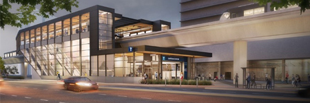
The Capstan Station on the Canada Line opened to customers on December 20, 2024. The station delivers more efficient rapid transit in the growing Capstan Village area of Richmond.
The new Capstan Station amenities include:
- Larger platform waiting area
- Expanded street-level concourse
- Dual sets of escalators
- First all-digital station with enhanced display screens
- Future commercial retail space
Construction timeline:
- Public engagement (Nov 2020)
- Station design completion (summer 2021)
- Construction (summer 2021 to winter 2024)
- Capstan Station opened to the public: Dec. 20, 2024
Neighbourhood Traffic Calming Program*
The City’s neighbourhood traffic calming objectives aim to transform local roads into people-first streets by:- Informing speed interventions with public engagement.
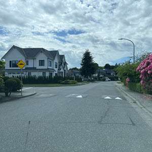
- Redesigning streets to discourage speeding.
- Enhancing the comfort of people walking, biking, or rolling.
The process includes the following steps:
- Multiple residents request speed management measures on their local street (A petition may be requested).
- Traffic studies are conducted by staff to measure road safety and operational issues.
- Staff collaborate with residents to develop tailored traffic calming measures based on the speed data results and site conditions to work towards achieving consensus.
- Surveys of affected residents determine the level of support for the proposed traffic calming measures developed during the engagement phase. Implementation subject to funding and/or City approvals.
*Note: implementation is subject to funding and/or City approvals.
Contact Information
To report a problem or request a service, use our Customer Feedback Form.
Transportation Department
transportation@richmond.ca 604-276-4271