
Flood Protection
How is Richmond Preparing?
 The City of Richmond is made up of islands within the floodplain of the Fraser River, where the river flows into the Salish Sea. At an average of 1 metre (3 feet) above sea level, Richmond faces flood hazards from coastal storm surges, snowmelt flooding and extreme weather events making flood protection incredibly important.
To ensure Richmond remains safe, the City has one of the most comprehensive flood protection systems in British Columbia.
Learn about events and opportunities to have your say on LetsTalkRichmond.ca.
Watch the City's Flood Protection animation:
Learn more about the City's Flood Protection System:
Explore the Flood Protection Story Map, an interactive tool that provides a great
starting point for learning more about City's flood protection system.
What’s Keeping Richmond Safe?
The guiding framework to upgrade and improve flood protection across the City in advance of sea level rise and other climate driven flood hazards are:
Our flood protection system is designed to:
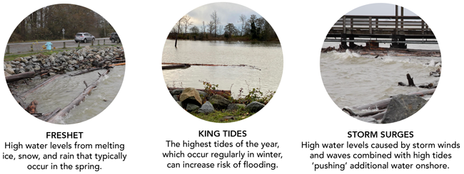
- Withstand high water events such as spring freshets and King Tides
- Handle a 1:500 flooding event: a major flood that has a 0.2% chance of happening in any given year
Current flood protection infrastructure includes:
- Dikes: 49 km of dikes that hold back the waters of the sea and river
- Drainage pipes: 598 km of drainage pipes that transport water out of the city
- Culverts: 61 km of culverts that carry streams and store rainwater
- Channelized watercourses: 151 km of channels that move water through and out of the city
- Pumps: 39 drainage pump stations that pump rainwater out of the city
- Sensors: Numerous flood protection sensors that provide real-time data on river levels, rainfall and stormwater drainage
Pump Stations
Since the early 2000s, Richmond has rebuilt and upgraded 19 drainage pump stations, increasing the total pumping capacity by 30%. These stations are now capable of discharging approximately 1.4 million US gallons of water per minute - the equivalent of over two Olympic swimming pools. The current focus is now shifting towards dike raising from the current elevation of 3.5 metres to 4.7 metres to stay ahead of sea level rise.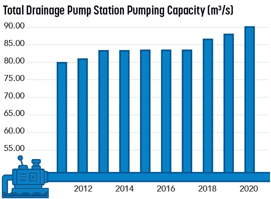
Planning for Change
The City of Richmond recognizes that even with global climate change mitigation efforts to reduce greenhouse gas emissions, there are predictions of environmental changes that will occur even if global emissions are drastically reduced. This includes 1 metre of sea level rise and increased rainfall for coastal communities.
To ensure Richmond remains safe, the City is continuously upgrading flood protection measures.
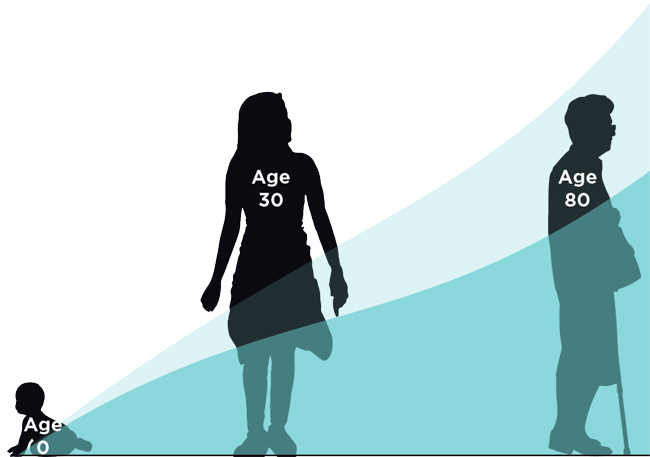
A lifetime of sea level rise. The graphic above shows how a person born today can expect around 50 centimetres of sea level rise by the time they are 30, and around 1 metre of sea level rise by the time they are 80. The lighter blue line shows a higher range of sea level rise that could occur if global carbon pollution targets are not met.
Sea Level Rise
With climate change, warmer temperatures melt glaciers and ice caps and increase the temperatures of the ocean causing the water to expand. As a result, global sea levels are rising. Sea level rise increases flood risks posed by King Tides and coastal storm surges.
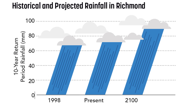
The Province of British Columbia advises municipalities to plan for 1 metre of sea level rise over the next 80 years. During this same period, land in Richmond is expected to subside, or lower, by 0.2 metres.
Increased Rainfall
Over the past 20 years, the average intensity of rainfall events in Richmond has increased by approximately 15%. With climate change, this trend is expected to continue. Powerful rainfall events can intensify coastal storm surges and river flood hazards due to the incased river flow.
City Plans & Preparations
Flood Protection Management Strategy
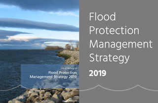 A key action identified in the City's Flood Protection Management Strategy involves continuing to upgrade the City's perimeter dike in anticipation of climate change induced sea level rise.
Read the Flood Protection Management Strategy
Dike Master Plan
The City's Dikes Master Plan outline the process to upgrade the City's dike in advance of sea level rise and other climate change flood hazards and has been divided into the following phases: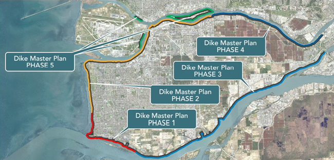
Learn more about the Dike Master Plan.
Community Energy and Emissions Plan
 Richmond's Community Energy and Emissions Plan 2050 includes actions that will set Richmond on a path to reduce community greenhouse gas emissions by 50% by 2030 and reach net zero emissions by 2050. These targets are consistent with the United Nation's 1.5C global warming limit.
Read the Community Energy and Emissions Plan
Additional Resources
Frequently asked questions
Flood protection flyer
Flood protection flyer (繁體中文)
Fact sheets - Climate change and flooding
Flood protection infographic
Flood protection timeline
Drainage overview graphic
Drainage Tips for Property Owners
FloodProtection@richmond.ca 604-204-8521