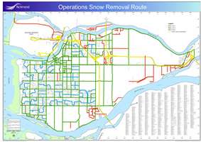
Snow Response Route Map
During storms, the City ensures all major roads are cleared and sanded so that emergency vehicles (ambulance, fire trucks and police), public transit and private vehicles are able to travel key routes.
- First priority routes (217 km of road) are salted/sanded or cleared first. First priority routes include all bus routes and section line roads (i.e., No. 1 Road, No. 2 Road, No. 3 Road, etc.)
- Second priority routes (22 km of road) are main collector roads through major subdivisions and industrial roadways as shown on the Snow Response Route Map.
- Third priority routes (77 km of road) are only serviced once the first and second priority routes are cleared and under control. If conditions deteriorate, crews will cease operations on the third priority routes and re-focus resources on the first and second priority routes.
To view a larger map with details download a PDF version: