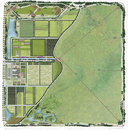
Garden City Lands

 The Garden City Lands are an extraordinary 55.2 hectares (136.5 acres) of open space located within the Agricultural Land Reserve, in the heart of Richmond, between Westminster Highway, Alderbridge Way, Garden City Way and No. 4 Road. The Garden City Lands will become a major new community park with diverse uses, including urban agriculture, environmental preservation and interpretation, recreational and cultural uses.
The Garden City Lands Park Development Plan represents the synthesis of the original Garden City Lands Legacy Landscape Plan endorsed by Richmond City Council in 2014, with new science-based recommendations as well as the feedback the City received from hundreds of Richmond residents and the contribution of Kwantlen Polytechnic University regarding agricultural production. Council has approved funding for the phased implementation of the Garden City Lands Park Development Plan.
To review the Development Plan and an enlarged version of the Legacy Landscape Plan above, see the following PDF document: GCL Park Development Plan - PDF
The Park Development Plan key components includes:
- The Agricultural Lands
- The Bog
- The Rise
- The Nodes
- The Dyke
- Perimeter Trails
For more details about the above key components, visit the Garden City Lands Archive page.
The Perimeter Path
As per ALC restrictions, the interior of the site is closed to public access. Stay on the perimeter path. Only City staff and KPU personnel are permitted within the site at this time.
Future Improvements Update
In 2025 the following site improvements are planned for construction as weather conditions permit:
- Soil and Groundwater Quality and Monitoring Study
- Continue with the sourcing and placement of soils for the KPU Farm fields
- Ongoing tree and shrub planting on the site
- Further studies of the site’s bog ecology, hydrology and plant communities
- Ongoing regular park maintenance
- Supporting KPU’s farm activities on the site
Construction activities will be ongoing utilizing portions of a previously approved budget of approximately $2,000,000. See signage on site and the project web page for updates, including construction photos and videos.
The public is welcome to enjoy walking on the Lands beyond just the 2.9 km perimeter recreational trail. Access within the site is permitted on the gravel farm roads and paths only. Please do not enter KPU’s farm area or facilities as well as the ecologically sensitive bog habitat areas. Foraging and collecting food from KPU’s farm fields is not permitted.
KPU at the Garden City Lands
Previously Completed Works
Since 2017, the following site improvements and activities have been conducted on the Garden City Lands:
- Perimeter pedestrian and bicycle paths (opened for public use in summer, 2018)
- Completion of the seepage barrier along the central dyke and along Westminster Highway
- Installation of site infrastructure (drainage ditches, storm sewer connections and weir structures, electrical and water connections; drain tile in KPU fields; water features)
- Placement of soil for the initial phase of farm development (2.7 ha)
- Hydroseeding of exposed peat soils along paths
- Fall/wnter tree planting along the perimeter
2017 Construction Photo / Video - Drone Footage
September 2017
Mid-May 2017
February 2017
Press the play button and then the square button in the bottom, right-hand corner to watch the 2 minute Garden City Lands drone video in full screen HD. To move through the video more quickly, grab the "playhead" and drag it along the timeline.
For more information:
Alex Kurnicki
Manager, Park Programs Alex.Kurnicki@richmond.ca 604-276-4099
Related Documents and Resources
Water and Ecological Resource Management
To review the Water and Ecological Resource Management Plan, see the following PDF documents:
WERMS - Table of Contents
WERMS - Executive Summary
WERMS - Site Assessment
WERMS - Ecological Resource Management
WERMS - Water Resource Management
WERMS - Operations Management
WERMS - Appendix A

