
Ecological Network
 The Ecological Network concept was first introduced in the City’s new 2041 Official Community Plan, in Chapter 9: Island Natural Environment (an Ecological Network Approach). This section of the OCP provides direct support for the development of an Ecological Network concept in Richmond. The Ecological Network is defined by Richmond's natural and semi-natural areas, including terrestrial, shoreline and riparian zones.
Ecological Network Management Strategy
In order to protect, enhance and expand a diverse, connected and functioning Ecological Network, Richmond City Council adopted the Ecological Network Management Strategy in September 2015. The strategy provides a framework for managing and guiding decisions regarding the city-wide system of natural areas in Richmond and the ecosystem services they provide on City, public and private lands. This strategy, intended to be opportunistic and collaborative, will set out priority areas, initiatives and projects for the on-going and long-term implementation of the Ecological Network (EN). There are many City actions, initiatives and projects currently underway that are supported by a range of regional and City policies, regulations and plans. The Strategy will seek to complement, align and inform the current planning and regulatory context in order to strengthen and enhance Richmond’s natural spaces.
Ecologically valuable areas in Richmond (regardless of ownership) are identified as part of the Ecological Network. This includes larger areas such as Richmond Nature Park, Terra Nova Rural Park, Sturgeon Bank, South Arm Islands, and smaller areas such as backyards, parks, school yards, fields and meadows. These areas support habitat for birds and wildlife, including migratory shorebirds and waterfowl, and salmon mudflats. The protection and enhancement of the EN enriches the health and livability of our communities and provides access to nature within our increasingly urban neighbourhoods.
Ecosystem Services
The Ecological Network also provides critical 'ecosystem services', which are the benefits that the city and its residents obtain from the environment. These ecosystem services contribute to the ecological health of water, air and soil and the well-being of residents. Ecosystem services provided by the Ecological Network include:
- Rainwater storage and filtration
- Erosion protection
- Areas for wildlife foraging
- Food production
- Pollination
- Recreation and scenic areas
Green Infrastructure
 Green infrastructure is also a key part of the Ecological Network, especially in more urbanized areas that may lack natural or semi-natural areas. Green infrastructure complements more traditional infrastructure (i.e. roads, sewers) and is often comprised of engineered components that employ natural features. Green infrastructure advances the resiliency and sustainability of City infrastructure, and examples include:
- Stormwater ponds that capture rainwater and reduce runoff
- Riparian corridors that capture and convey runoff, but also provide habitat
- Agricultural hedgerows and trees that support wildlife habitat
- Community gardens that support pollinators
Ecological Network Maps
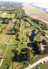
An updated Ecological Network map identifies the hubs, sites, shoreline and riparian areas, parks, and corridors that comprise the network of ecological assets in Richmond. Ecologically valuable areas vary in size and land use characteristics, and have been identified regardless of ownership, as they support habitat for birds and wildlife, and provide critical ecosystem services. Much of the EN is located outside of the dike, or within the Agricultural Land Reserve, highlighting the importance of collaborative actions to manage the EN.
The Ecological Network Strategy Areas map highlights the approach to guiding the application of the EN throughout the city. Strategy areas geographically characterize Richmond based on vegetation type, land-use and stewardship and development opportunities. The purpose of using Strategy Areas as the framework for EN application is four-fold:
- To provide an overview of Richmond’s current ecological assets;
- To identify and group areas of Richmond to focus future specific actions where most appropriate;
- To tailor guidance on how the EN can be strengthened within different vegetation and land-use types within Richmond; and
- To identify the unique conditions that pertain to the enhancement and enrichment of the EN in specific areas.
Environmentally Sensitive Areas
The City of Richmond is surrounded by environmentally sensitive areas. The marshes, wetlands, beaches and open spaces we have today need to be preserved for the future. Our common environment depends on the sustainability of Richmond's natural areas. By being involved in the preservation and maintenance of these environmentally sensitive areas, the community will be helping to save our unique waterfront and bring positive results to an already fragile ecosystem. If the community becomes involved in the maintenance and care of these areas, we can preserve and enhance the global treasure in our backyard.
Individuals, groups, schools and environmental groups are encouraged to work hand-in hand with the City to adopt an environmentally sensitive area. Liaison with Federal and Provincial agencies may be required for some projects. Examples of adoption may include:
- Litter control;
- Select and target a specific area for clean up and restoration;
- Educational programming;
- Development of interpretative signage and or classroom materials; and
- Bird box installation.
Private organizations are also encouraged and challenged to participate in this program. By participating in Partners for Beautification, businesses and groups can be involved in clean up and maintenance projects to preserve Richmond's environmentally sensitive areas. The City will offer technical guidance and provide required equipment for adoption on this category.
For more information, please contact the City of Richmond Parks Department at 604-244-1208.
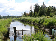
Bath Slough Revitalization Initiative
Bath Slough, as one of the few remaining natural watercourses in Richmond is today a key part of the City's Ecological Network. The slough is an ecological corridor linking the Fraser River and the interior of the island, and it provides ecosystem services such as wildlife habitat and storage and conveyance of rain water. In addition to its ecological benefits, Bath Slough is well-situated as a greenway for recreation and transportation, as it connects the Cambie Community Centre and surrounding neighbourhoods with the bustling Bridgeport retail and industrial operations, and the Fraser River.
In April 2014, Richmond City Council adopted the Bath Slough Revitalization Initiative, to create a unique urban enhancement and stewardship program to revitalize the community amenity and further the goals of the Ecological Network. The Bath Slough Revitalization Initiative will create a revitalized and activated corridor, with improved access for the community. This initiative is envisioned to consist of several inter-related elements designed to target different user groups and constituents, such as community mapping, ongoing capital and operational projects, resident stewardship, industrial stewardship & outreach, and special events.
Activities to support this initiative have included community workshops in Summer 2014 (at the Cambie Community Centre) to identify issues and opportunities for improving Bath Slough. Tree and shrub planting in Bath Slough took place in Fall 2014 as part of TD Tree Days. Further, a pollinator pasture has been established in Bridgeport Industrial Park, as part of the efforts to revitalize Bath Slough (see below for more details).
Bridgeport Industrial Park Pollinator Pasture
Video coming soon!
The City undertook ecological enhancements to Bridgeport Industrial Park, as part of the Bath Slough Revitalization Initiative. In 2015-2016, The City created a 'pollinator pasture' (wildflower meadow) within the park, which is adjacent to Bath Slough. The pollinator pasture, a collaborative project with Emily Carr University of Art and Design, benefits a multitude of essential pollinators, including native bees and butterflies, and strengthens ecological links between Bridgeport Industrial Park and Bath Slough. It included the following initiatives:
- A cover crop was planted and bloomed in June and July, helping to stabilize the soil and prevent weed growth. The cover crop included a pollinator-friendly blend of yellow mustard, sweet alyssum, crimson clover, and phacelia.
- Cambie Secondary School Ecosaders team planted a sunflower wall in the northwest area of the park, with seedlings grown in their classroom.
- The seeds of the yellow mustard plants were harvested by students from Kwantlen Polytechnic University Farm School, as an educational exercise in harvesting and mustard production
- Installation of log seating at either end of the park, as well as two apiaries (insect hotels) featuring educational panels on pollinators.
- A new pasture design was planted, anticipated to bloom in Spring/Summer 2016. The 2016 pasture includes native wildflowers planted along the length of the park in the pattern of the lower wings of the native Western Bumblebee.
- A number of activities are being delivered to program the park and spread awareness about the importance of pollinators and stewardship of Bath Slough.
British Columbia, V6Y 2C1 EnvSustainability@richmond.ca 604-247-4661