
BC Packers Insurance Photographs and Maps
British Columbia Packers Limited was at one time the largest and most diverse fishing company in Canada. For many years, the company operated out of headquarters in Steveston, a major centre for the British Columbia fishing industry for much of the last century.
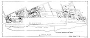 |
| Steveston waterfront and surrounding area, late 1970s. City of Richmond Archives, map 2001 34 3-548. Click here to view enlarged map. |
In 2001, after the company had closed its head office doors in Steveston for the last time, its records were donated to the City of Richmond Archives.
In the summer of 2007, the Archives began a project to scan and make available online 887 insurance maps and photographs.
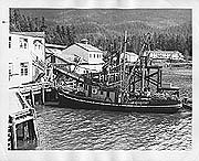 |
| Table seiner Gospak in Namu harbour, July 1948. The cannery here no longer exists. City of Richmond Archives, photo 2001 34 9-383. Click here to enlarge image. |
The maps and photographs document the company's operations over time, through periods of economic expansion and decline, and intense technological change.
The images also record the lives of those people whose livelihood depended upon the industry.
They reveal the daily activities of the fishermen at sea, the workers on land at the various plants and other facilities, as well as the communities that sprung up and were centred around them, some of them no longer in existence.
The records are evidence of the insurance needs of the company. British Columbia Packers Limited insured their fleet, buildings and products. In the days before digital cameras and email, the insurance companies sent appraisers into the field to photograph buildings and draw site maps. The images and maps would then be appended to the appraisal documents. While the appraisal documents are no longer available, the images and maps are.
You can search the entire collection of insurance maps and photographs:
- BC Packers Insurance Photographs and Maps Database
You can explore a sample of the maps and photographs that are part of this project by viewing the following galleries: - Photograph Gallery
- Maps and Plans Gallery
You may also use the following links to learn more about the company and this exhibit: